Friday, October 26, 2018

Fiji extreme weather

Fiji fortunately is not the worst country when it comes to extreme weather. Though, it still experiences weather conditions that are a tad extreme. For instance big storms.
The storms that affect Fiji may sometimes turn deadly. As storms eventually turn to cyclones (we'll talk about cyclones another time) they can damage homes, flood businesses, and even kill people. Luckily storms are on watch out in Fiji as Meteorological Services alert the people of the country as best as they can. Big storms do not frequent as much as there is good weather in Fiji though. That is the reason the islands create such a good vacation spot. 


Image result for fiji extreme weather


Image result for fiji extreme weather


Sources:

https://www.fijimarinas.com/climate-weather-fiji/
20121213_TC_Evan_IMG_0811.jpg 
https://www.fijitimes.com/weather-watch-heavy-rain-warning-downgraded/

Friday, October 12, 2018

Mass Wasting

Fiji is an area that hosts many rainfall patterns and rough topography which see some earthquakes that may make localized landslides a frequent hazard. As you can see below in the picture, much rain hits the eastern islands yet also affects the middle and western islands as well. Rain causes uneven soil to be pulled down with gravity causing, in some cases deadly, landslides.
Image result for landslides in fiji map
Warning Systems/ Pre-cautions 
I could find no warning systems set up in Fiji currently for landslides. It appears as though they are relying mostly on measures set up for other hazards. For example they have preventative measures and tips for, cyclones, droughts, earthquakes, floods, etc. However, no mass wasting. I would like to think a few tips from Fiji's flood section on their National Disaster Management Office's web page would carry over into mass wasting protocol. I have provided below a picture for the example of the useful tips in the flood section. 

Sources: 


Friday, September 7, 2018

Fiji Seismicity

Seismicity: 


Due to the location of Fiji, earthquakes happen to be often but never taken for granted. Earthquakes generally happen on the eastern Pacific plate the Fiji lies on. Though there have been noted earthquakes to happen along the Indo- Australian plate as well, since Fiji is in the middle of both plates. According to the USG website, this week alone there have been 10 earthquakes ranging from a 4.3 magnitude to a 7.9 which hit most recently (9/6/18). Earthquakes and their damage are prominent throughout the area as you may see in the picture below.


Preventative Measures: 


With earthquakes frequently hitting the country, the threat for tsunami's is of seemingly greater importance. Fiji's National Disaster Management Office (FNDM) has set precautions throughout a few primarily and secondary schools. The schools targeted for the drills that the FNDM set up are those along the Suva Tsunami Hazard zone. It just so happens that the 7.9 magnitude quake on 9/6/18 rocked Suva as it was merely 63 mi from the epicenter.


Sources:
https://earthquake.usgs.gov/earthquakes/eventpage/us2000h9e2#executive 
https://earthquake.usgs.gov/earthquakes/map/
index.phtml
https://www.youtube.com/watch?v=TPlLnH83W18&feature=youtu.be

Friday, August 31, 2018

Tectonic Plates

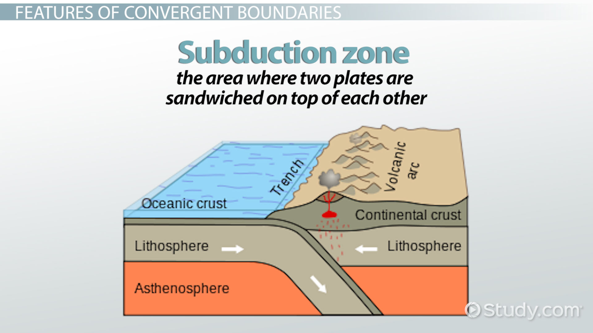
Fiji is located at the Indo-Australian and the Pacific plate boundary. As a result, Fiji is considered to be on the Pacific ring of fire with countries such as Argentina, Brazil, Guatemala, etc. Due to this feature of two plate boundaries, Fiji finds itself in the midst of two opposite facing subduction zones which lead to the formation of volcanoes and the threat of earthquakes.

Also, Fiji's tectonic history cannot be explained equally but instead into two separate stages. Stage one: 40-28 million years ago is defined by the continuous volcanic island arc system, known as the Vitayaz Arc. The arc was formed by subduction of the Pacific plate under the Indo—Australian plate. Stage two: 28-12 Million years ago was defined by the diagonal north subduction of the Pacific plate under the Indo—Australian plate. Subduction was therefore a particularly shallow angle to the plate boundary. This all essentially means Fiji was caught under a period of increased stress on the tectonic plates which only increased the uplift of volcanic rocks and formations across the islands. 
Image result for two opposite facing subduction zones
This is what the subduction zone Fiji finds itself in is like.


Image result for what kind of tectonic plate is fiji on
As you may see through the map key, Fiji lies in between the Indo-Australian plate and Pacific plate in a subduction zone. 


Sources: 
Link to article: http://www.mrd.gov.fj/images/Brochures/Plate_Tectonic.pdf
Link to first image: https://study.com/academy/lesson/convergent-boundary-definition-facts-examples.html
Link to second image:http://www.mrd.gov.fj/images/Brochures/Plate_Tectonic.pdf

Sunday, August 26, 2018

Hazards, Disasters, and Catastrophes

Hazards:
Hazards are natural events that pose damage and life threat to human life and property. A natural process, such as a volcano, may only become hazardous when people are inhabiting the space in which  the volcano erupts in.
Disasters:
A Disaster is an event that has been deemed hazardous, has a defined area, and has occurred over a limited time span. In order for a disaster to be specified as such, one of four criteria must be met:

  • 10 or more people killed
  • 100 or more people affected
  • Declared state of emergency 
  • International assistance request

10 people killed
•
≥
100 affected
• Declared state of emergency
• Requested international assistance≥
10 people killed
•
Catastrophes: 
Catastrophes are immense disasters that take ample amounts of time, money, and resources to recover. In recent memory hurricane Harvey is an example of such an event.